Origins of Grangetown's street names
By Ray Noyes and Zena Mabbs
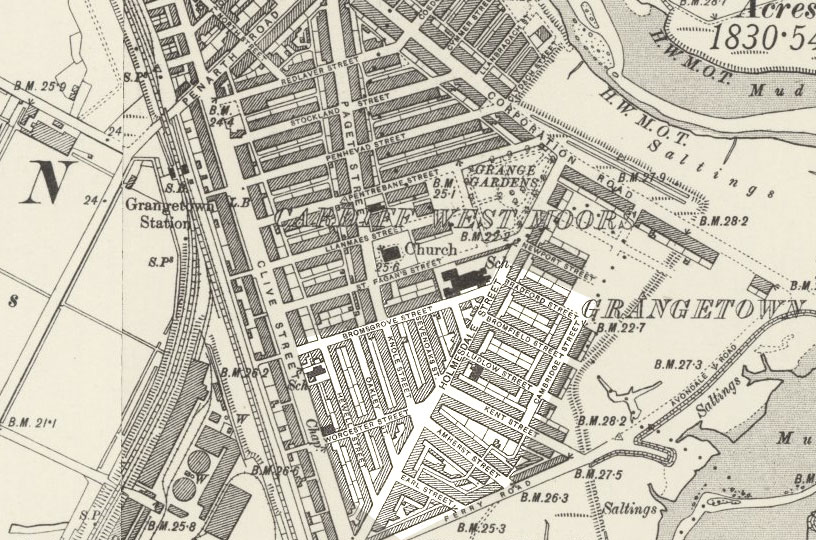
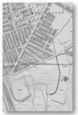
The area we are talking about here is Lower Grangetown - highlighted on the map above and contained between Clive Street, Bromsgrove Street and Holmesdale Street as far as Newport Street and Ferry Road. These streets and houses were constructed during Phases 1 and 2 and were named after members of the landowning aristocratic family, the Windsors, or their investors:
Phase 1 (1857 - 1865 built by the Windsors under the 1857 Act): York Place, Clive, Holmesdale, Oakley, Hewell, Knole, Sevenoaks, Bromsgrove, Worcester, Earl, Amherst, Kent.
Phase 2 (1865 - 1876 built by the Windsors under the 1865 Act): Forrest (Herbert), Ludlow, Bromfield, Bradford, Newport, Llanmaes (west), St Fagans (west).
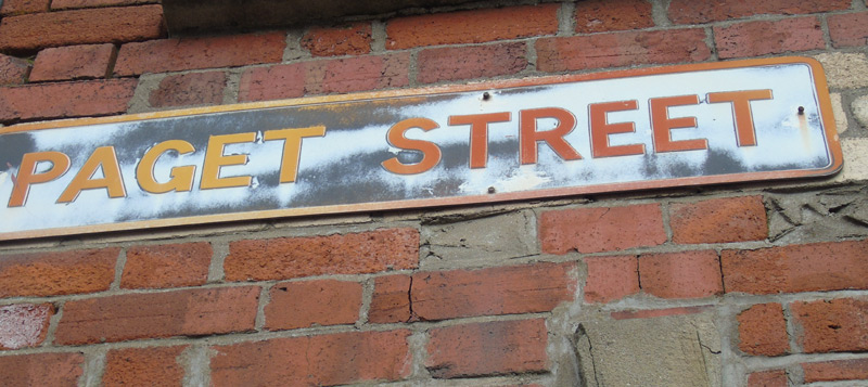
Phase 3 (1876 onwards built by the Windsors under the 1876 Act): Paget, St Fagans (east), Llanmaes (east), Pentrebane (part), Penhevad (part), Stockland (part), Redlaver (part). It used Paget Street as a "spine" from which lesser streets branched. It marked a major departure in house design from the terraced cottages in Lower Grangetown. These branching streets were all named after farms on the Windsors St Fagans estate.
Phase 4 (1882 onwards by Butes): Grange Gardens, Pentrebane (east), Penhevad (east), Stockland (east), Ferndale, Blaenclydach, Coedcae, Cymmer, Llanbradach, Clydach, Bargoed, Aber, Ystrad, Abercynon, Taff Terrace, Taff Embankment. Phase 4 was exclusively built by the Butes and was focused on the eastern (Taff side) of Grangetown. Here, the street names derive from industrial links with the coal industry rather than the names of family members or investors.
Corporation Road had been a road since the creation of tithed land after the abolition of the monasteries. It was then known as Moore Road and was a flood barrier, protecting the land from the Taff. A road of sorts had been established on top of this.
Areas and how they were developed during each phase
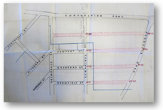
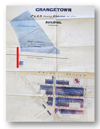
The above plan (left) shows the extent of Phase 1 by the Windsors. Pictured above right is shown the eastern limit of Phase 2, with the Marquis of Butes future streets indicated in red. These would extend to Avondale Road. Newport Street was the furthest extent of Phase 2 under the Windsors. The plan was drawn up to show how the Butes intended continuing construction on their land so as to blend in with that completed by the Windsors. Pentrebane Street had been drawn in, but had not yet been constructed. An area was reserved for Grange Gardens.
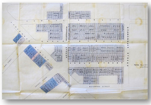
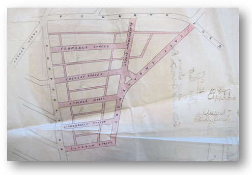
Below is shown the plan signed by the Marquis of Bute approving the layout and names of his streets in the northwest of Grangetown, between Corporation Road and the Taff.
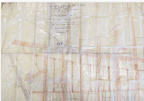
The largest single spurt in construction occurred along Paget Street and then eastwards to Corporation Road. The original street layout under the Windsors is shown below, albeit indistinct. Clusters of custom-designed shops were to be provided along Paget Street. It is shown below.
Shown in red are the streets to be constructed under phase three. We can see that towards Corporation Road and the Taff no housing was drawn on the plan because the land belonged to the Butes. The meandering shape where the Windsor streets end (in red) reflects the boundary of the original tithed plots into which the land had been divided and the parish boundary. Basically, the Windsor lands came under the diocese of Llandaff, whereas the Bute lands came under St Marys (Butetown).
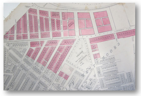
This final housing plan above shows how the construction of housing on the Bute streets was halted at Clydach Street due to the then inadequacy of the Taff river embankment to protect the area from flooding. A proper flood embankment was not constructed until well into the twentieth century. The land to be left undeveloped is shown in plain blocks of pale red. The plan also shows that the relatively modern housing either side of Corporation Road hadnt yet been sketched in and is uncoloured.
The influence of flood defences
 It should be noted that not only were the houses in the lower Grangetown area (Phases one and two) damp from the marsh, but the area flooded regularly.
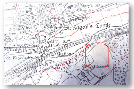
This map (pictured left) from 1915 shows the extensive dykes that had been built to protect the area. They were often breached by high Spring tides. One disastrous breach occurred in the dyke at Kent Street in 1883, not only flooding but partially destroying the foundations that were being laid for Grangetown School. In this map, the Taff is on the lower right. The dykes are shown as meandering embankments.
The stadium shown at the bottom left was once an extensive marl clay pit, which gave rise to the name of the park, The Marl.
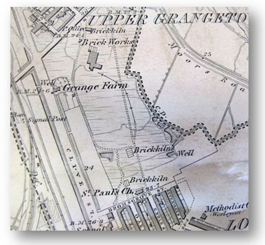
The marl clay fed large-scale brick manufacturing activities on the Grange in two factories, both of which were bought by the Windsors. They then sold their own bricks to housing developers on Phases 1 and 2. The works are shown in the map below.
We shall see that the names given to streets by the Windsors were those of family members (eg Clive) or those of investors (eg Holmesdale). The legacy of those who invested in Grangetown is literally written in its street names.
The Marquis of Bute, on the other hand, chose to name his streets (those mainly to the east of Corporation Road) after one of the sources of his wealth - collieries. The following shows where most street names originated and shows the original correct spelling where this has been corrupted.
The corruption of street names is particularly evident in Welsh names. Penhevad Street, for example, was named after the Pen-Hefyd Farm on the Windsors estate of St Fagans.
Similarly, Redlaver Street should have been Rhyd-Lafa. It may be that the names were dictated, rather than being written down.
Here again is a reminder of the four phases in which Grangetown was built and which are referred to in the following text: Phases 1 and 2 were named after Windsor family members, their estates or fellow investors: Phase 1 (1857 - 1865): York Place, Clive, Holmesdale, Oakley, Hewell, Knole, Sevenoaks, Bromsgrove, Worcester, Earl, Amherst, Kent.
Phase 2 (1865 - 1876): Forrest, Ludlow, Bromfield, Bradford, Newport, Llanmaes (west), St Fagans (west).
Phase 3 used Paget Street as a spine from which lesser streets would branch. It required a special Act of Parliament (1876) for its authorisation and marked a major departure in house design from the terraced cottages in Lower Grangetown. These branching streets are all named after farms on the Windsors St Fagans estate. 1876 onwards by Windsors: Paget, St Fagans (east), Llanmaes (east), Pentrebane (part), Penhevad (part), Stockland (part), Redlaver (part).
Phase 4 was exclusively built by the Butes and focused on the eastern (Taff side) of Grangetown. Here, the street names derive from industrial investments and industrial connections with the Marquis business interests. 1882 onwards by Butes: Grange Gardens, Pentrebane (east), Penhevad (east), Stockland (east), Ferndale, Blaenclydach, Coedcae, Cymmer, Llanbradach, Clydach, Bargoed, Aber, Ystrad, Abercynon, Taff Terrace, Taff Embankment.
Corporation Road had been an ancient road to the grange marshes, known as Moore Road, and was a flood barrier, protecting the land from the Taff.
Ferry Road needs no explanation and is not examined in this paper - Ferry Road does what it says. There were two ferries: one from approximately the Sand Wharf (today) to the Hamadryad point; and the other from a point north of the old subway entrance, across the Penarth (Ely) Harbour to Penarth Docks.
ABER STREET Aber Colliery was near Tynewydd in the Ogmore Valley. It was one of the earliest collieries in the area. The Marquis of Bute was a major customer for its coal. Here it is shown in its earliest years, possibly in the 1860s.
ABERCYNON STREET Abercynon Colliery was situated at the junction of the Taff and Cynon Valleys. It was sunk by the Dowlais Iron Company between 1889 and 1896 to supply the steel works at Cardiff.
 AMHERST STREET
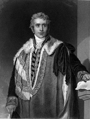
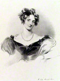
The Right Honourable Lord William Amherst was the 1st Earl of Amherst (1773-1857, pictured right), stepfather of Baroness Harriet Windsor and Governor-General of India. He invested in Grangetown and guaranteed loans to her. He was awarded his earldom for military excellence at Montreal, Canada. He built Montreal House at Sevenoaks, Kent (now demolished).
AMHERST STREET
The Right Honourable Lord William Amherst was the 1st Earl of Amherst (1773-1857, pictured right), stepfather of Baroness Harriet Windsor and Governor-General of India. He invested in Grangetown and guaranteed loans to her. He was awarded his earldom for military excellence at Montreal, Canada. He built Montreal House at Sevenoaks, Kent (now demolished).
AVONDALE ROAD This was an estate in South Lanarkshire, Scotland, which became part of the 2nd Marquis of Butes estate when he married into the Dumphries family. It borders the river Avon and is at the bifurcation of a valley into two vales. A Roman road passes through the area and leads to a Roman fort at Loudon Hill. Loudon parish adjoins Avondale, both names used by the Butes - Loudon Square being in Butetown and Avondale Road in Grangetown, bordering the river, as it does in Scotland.
BARGOED STREET This colliery was one of the best performing in the UK. It held the record for the most coal (tonnage) raised in 24 hours. It was owned by Powell Dyffryn which also owned Coedcae.
BLAENCLYDACH STREET This short street at the northern end of Taff Embankment is also named after a colliery in the Clydach Vale, adjacent to Tonypandy. Its output was principally used for manufacturing coke on site in large coke ovens. This was used in the manufacture of Haematite and Bessemer pig iron. The Forest Iron and Steel Co. later purchased Blaenclydach colliery for just this purpose, providing coke for their Pontypridd furnaces. But it was also shipped, as a finished product for export and was used in various Cardiff iron works. It is possible that the iron works at Grangetown (named the Penarth Iron and Steel Company) also used it. It was an essential ingredient for making steel. So large was the demand for good quality coke, that the Marquis of Bute set up a coking export business when the quality of the coke gave rise to significant demand from the furnaces of Europe. Although a considerable quantity of the so-called No.2 and No.3 Rhondda variety of coal was carbonised at the pithead for the production of coke, few attempts were made to recover any of the other valuable products of the distillation of coal until the early twentieth century. Tar, creosote, pitch and hydrocarbons were simply burned off. The marquis, however, established a creosote business on the banks of the canal near Butetown adjacent to a new coking works..
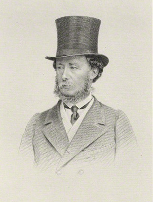 BRADFORD STREET Orlando Charles Bridgeman, 3rd Earl of Bradford (1819-1898, pictured left), was an investor in Grangetown. His name appears on the lease of houses in Kent Street and Oakley Street, which are lodged with the Glamorgan Archives. Before he became the 3rd Earl, he was Viscount Newport. [See also Newport Street.]
 BROMFIELD STREET Bromfield was an estate owned by the Baroness Windsor and the Windsor-Clive family. Baroness Windsor (pictured right) was buried there on 16th November 1869 at the church of Bromfield, Shropshire. She was buried in a vault with her late husband the Hon Robert Henry Clive (second son of the First Earl of Powys of the Clive branch) and her second son Robert Clive, who died in 1859. Shropshire and Worcestershire were the adopted counties of the Windsor-Clive family. They owned another estate at Ludlow.
BROMSGROVE STREET Bromsgrove Park was an estate of the 6th Earl of Plymouth (1789 - 1833) and he is buried there. He died without issue and the baronetcy was suspended. His legacy provided a major portion of the finance for Grangetown. He was colonel-in-chief of the Worcestershire Yeomanry Regiment. It is a parliamentary constituency, for which he was its MP. It is located in the county of Worcester, the county seat of the Plymouths.
CAMBRIDGE STREET No clear indication of the origin of this street name has been found, except that the Hon Robert Windsor-Clive (1824 - 1859) attended St Johns College, Cambridge.
The photograph left is of Robert Windsor-Clive.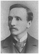 CLIVE STREET This was named after the Windsor-Clive dynasty. At one point, it was debated within the family whether the new town ought to be Clivetown rather than Grangetown; but it was rejected by Baroness Windsor. In 1857 she wrote: The subject of a name for the new Town we may now expect to see spring up on the Grange and Robert [Windsor-Clive] is more disposed that it should bear the name of the locality rather than that of Clive. Grangetown would be very suitable for various reasons and is I think the best - the name of Clive may appear for the principal street.
CLYDACH STREET This is one of the Butes streets. It was a colliery in the Lower Rhondda valley. The Clydach Vale area (Clydach Vale is a village near Tonypandy, on the Nant Clydach river) was particularly rich in good quality steam coal and contained a number of famous and very productive collieries. They all tapped into a rich six foot seam of steam coal known as the Coffin Seam (after its discoverer Mr Coffin) which was of the finest quality. So much coal was being shipped out of Clydach Vale that it caused congestion on the railway to the Bute Dock. The marquis invested, with others, in improving the Taff Vale Railway as a means of alleviating this congestion. His colliery investments in the Vale included the famous Cambrian Colliery which had its headquarters building in Butetown. At its peak in the 1890s it employed 4,000 men.
COEDCAE STREET This is also one of the Marquis of Butes streets on the east side of Grangetown. The marquis was an investor in the Powell Dyffryn company which took over the ownership of the Bertie, Coedcae, Hafod, Lady Lewis and Trefor Collieries. This colliery was extracting steam coal from the same seam as that at Clydach Vale.
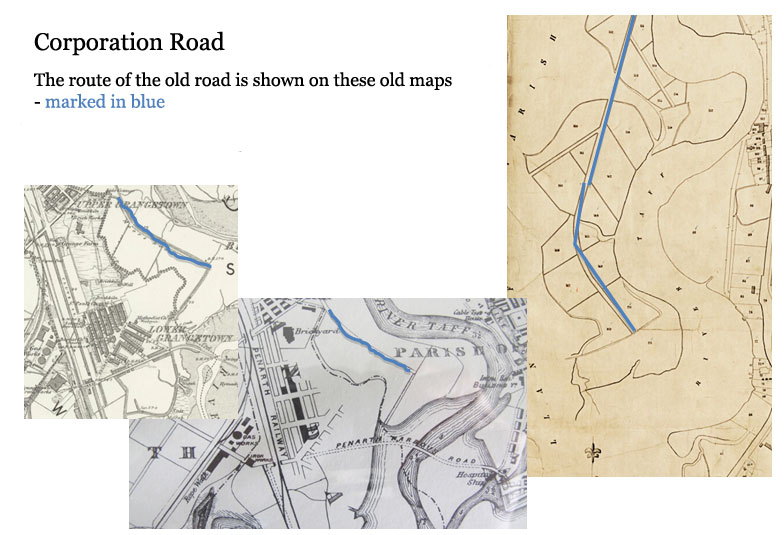
CORPORATION ROAD A road along the same route as the current one had long existed. Initially, it was a track on top of a flood barrier and is shown on old tithe maps, shown with other maps above in blue. We can assume that once Grangetown came into the Borough of Cardiff (1875) that the corporation saw the need to upgrade it in order to carry traffic to the burgeoning docks. The date of this upgrade has not been established.
EARL STREET It is possible that this street took its name from the Earl Amherst, who became Viscount Holmesdale, but it is not clear. See AMHERST STREET for details.
FERNDALE STREETT his was one of the oldest collieries in the Rhondda, sunk by David Davies in 1857. It was the first colliery to produce steam coal. It was also known as the Blaenllechau Colliery. It suffered a major explosion in 1867 when 178 men and boys died.
FORREST STREET This short street running parallel to Sevenoaks Street is listed on a 1915 map as Forrest Street. But there are suspicions that it may once have been named Herbert Street. On some maps, such as this one of 1881, it is not named at all. It was built at the very beginning of Phase 2, Phase 1 having ended at Kent Street. If Forrest is to be its acknowledged name, it is quite likely that it was named by the Windsors after their faithful legal man, Robert Forrest, who operated out of St Fagans. It was he who handled all major legal matters for them, including the initial drafting of the 1857 Bill, various memoranda of understanding (such as for the Iron Works and gas works sites) and all major contracts - such as that for Clive Street and Holmesdale Street. He also drafted the 1876 Bill to construct Paget Street and Phase 3.
It should be said that Forrest was not, of course, the only key individual in the construction of Grangetown. There was a second man, Charles Edward Burnand, a surveyor, who certainly carried a huge amount of pressure, for it was he who looked after the complex logistics of the project and all the works on the ground. Perhaps the Windsors thought a legal man was more worthy than an engineer!
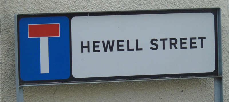
HEWELL STREET Baroness Harriet Windsor (1797-1869) lived at Hewell Grange, Tardebigge, Worcestershire. The property was sold to pay for death duties and is now a prison. (There is also a Hewell Road in Barnt Green in Worcestershire). The street was demolished in the 1970s although a short stub if it exists without housing.
HOLMESDALE STREET This was named after William Pitt Amherst (2nd Earl Amherst) who became Viscount Holmesdale (1805 - 1886). He was made a peer in 1826 and took his seat in the Lords in 1857, the very year that the Baroness of Windsor Act to construct Grangetown was debated. He died in 1886 at Montreal Park, Sevenoaks, Kent - an address which contains two other street names found in Grangetown.
Shown above is a lease for two houses in Kent Street dated 1874.
The original is in the Glamorgan Archives.KENT STREET
Orlando Charles Bridgeman, 3rd Earl of Bradford (1819-1898), was an investor in Grangetown. His name appears on the leases of houses in Kent Street and Oakley Street, which are lodged with the Glamorgan Archives. Before he became the 3rd Earl, he was Viscount Newport. He therefore has connections with several streets.
His sister married Robert Windsor-Clive, son of Baroness Windsor. Their home at Weston Park was gifted to the nation in 1981.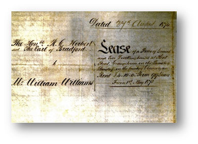
Knole House in Kent, which gave Knole Street its name
KNOLE STREET The Earl of Amherst lived at Knole House, constructed in the 15th century by Thomas Bourchier, Archbishop of Canterbury. Situated on top of a low hill or knoll, gave the house its name. At one time it was owned and inhabited by Thomas Cranmer. It is set in the great park of Sevenoaks. The Earl of Amherst passed away there. Knole Street was also lost to 1970s redevelopment.
LLANBRADACH STREET The Llanbradach No. 1 pit was sunk in1893 by Cardiff Collieries Ltd. The second pit was begun the following year. By 1913 it was one of the largest pits in South Wales employing 2832 men. It was closed in 1961. The colliery was situated north-west of Bedwas, Caerphilly.
LLANMAES STREET Llanmaes was a farm on the Windsors St Fagans estate. This street was the north-westernmost to be built as part of Phase 2 of Grangetowns construction before Paget Street was begun (1876). Its eastern side, leading to Grange Gardens was part of Phase 3.
LUDLOW STREET The Plymouth and Bute families inter-married. In 1758, the second Viscount Windsors daughter and heiress, the Hon Charlotte Jane Windsor, married John Stuart, 4th Earl of Bute. In doing so, the earl added the significant lands and wealth of the Stuarts to his already large fortune. In 1796 the Windsor title was revived when Lord Bute was made Earl of Windsor and Marquis of Bute.
The family seat was at Hewell Grange, Worcestershire, and is now at Oakly Park, Bromfield, on the outskirts of the borough of Ludlow, Shropshire. We can see that between them the families have links to several streets in Lower Grangetown. In the late 15th century, Edward IV founded the Council of the Marches of Wales with its headquarters in Ludlow Castle. De facto it became for a short while the capital of Wales.
NEWPORT STREET Viscount Newport, Earl of Bradford and 6th Baronet Bridgeman of Great Lever gave his name to this street. The earldom was revived in 1815 for Orlando Bridgeman (1762-1825), the 2nd Baron Bradford. The Bridgeman family had by then succeeded to the Newport estates. The title is not related to the city of Bradford, but refers to the parliamentary hundred of Bradford in Shropshire. We can see that the county had a number of links with the Plymouth family, their relations and antecedents. The peerage goes back to 1694. The family seat was at Weston Park, Staffordhire. It sits in 1,000 acres of parkland laid out by Capability Brown.
 OAKLEY STREET Although once a modest street, it nevertheless can claim a direct link with an impressive, landed family, the Earls of Plymouth. Shown here is Robert George Windsor-Clive, 1st Earl of Plymouth who was born in the same year (1857) that the Baroness of Windsor obtained parliamentary approval to build Grangetown. He was the son of the Hon Robert Windsor-Clive and Lady Mary Bridgeman. His father was the son of the Hon Robert Clive and Harriett, 13th Baroness Windsor.
His family tie to the Windsors was via his paternal grandmother. He was not a Windsor by birth but a Clive - from his father. His grandmother put a hyphen in her name upon her marriage and her son carried it on, becoming Windsor-Clive. When he came of age, he was intimately involved with the construction of Penarth Docks and Harbour scheme and one of the first directors of the Penarth Docks and Harbour Railway Company Ltd. He was particularly vociferous concerning the right of his family to retain Grangetown as part of Penarth and not relinquish it to Cardiff. He financed personally several legal battles over this issue; in particular with the Cardiff Water Company which wanted to supply Grangetown and Penarth with water. He threatened to form his own water company and gas companies to fend them off. Eventually, he lost these battles.
He commissioned the construction of Hewell Grange in Worcestershire (see earlier), which was completed in 1891. The estate had been the seat of the Windsor family since the 16th century. The family lived at St Fagans Castle during the summer months.
PAGET STREET Paget is a Norman name: a corruption of Pachet. Henry William Paget, 2nd Earl of Uxbridge, was a military leader who was created 1st Marquis of Anglesey after his exploits at the Battle of Waterloo. He built the family seat, Plas Newydd, at Llanddaniel in Anglesey. He died in 1854.
Alberta Victoria Sarah Paget (1863-1944, pictured above left) was the daughter of Sir Augustus Berkeley Paget and the Countess Walburga de Hohenthal. She married Robert George Windsor-Clive, 1st Earl of Plymouth (see above). As the wife of the Earl of Plymouth she was naturally aware of the investments at Penarth and in Grangetown. During WW1 she opened up St Fagans Castle as a hospital to treat the wounded and sick. She became a member of the Voluntary Aid Detachment (VAD) of volunteer nurses and in due course became president of the Glamorgan branch of the Red Cross. Alberta was also a Dame of Grace of the Most Venerable Order of the Hospital of St John of Jerusalem. Shown here are nurses and patients at St Fagans during WW1, generously supported by the Windsor-Clive family.
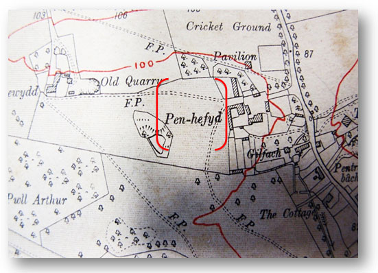
PENHEVAD STREET Penhevad is the corrupted form of the Welsh Pen-hefyd, a farm on the St Fagans Estate. There is no easy translation to its name. Hefyd means also. Pen means head, top, or end.
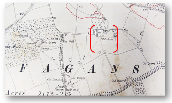
PENTREBANE STREET Pentrebane was also a farm on the Windsors St Fagans estate.
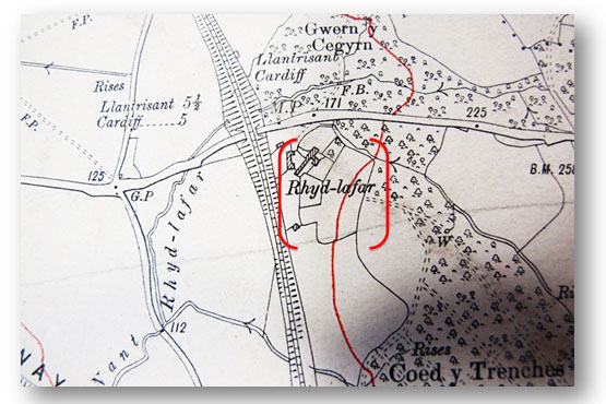
REDLAVER STREET This name is a corruption of its Welsh name: in this case, Rhyd Lafar. Rhyd means a ford or river crossing. A stream named Nant Lafar probably existed on the property and one can be seen on the map.
SEVENOAKS STREET Sevenoaks is the name of the large park surrounding Knole House, the home of the Earl of Amherst in West Kent. It is one of the largest parks in the UK. Knole House itself is one of the largest stately homes in the UK.
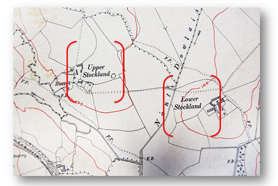
STOCKLAND STREET This is named after another farm (in fact there were two of them) on the St Fagans estate and they had a special significance for the Windsors. Upper and Lower Stockland farms at St Fagans had been run by a Mr Thomas Morgan who was asked to move to the Grange Farm to run it on behalf of the Windsors. It is therefore no surprise to find that he, or the Baroness, named the street on which Grange Farm was situated, Stockland Street. The postal address of the Grange Farm was, for many years, simply Stockland Street.
 ST FAGANS STREET The origin of this street name is not difficult to deduce. St Fagans was one of the Windsor-Clives estates from where the construction of Grangetown was directed - the projects headquarters.
WORCESTER STREET It is no surprise that there is a Worcester Street. It was one of the Earls of Plymouth host counties. Hewell Grange was the familys original country seat. It was sold to the state in the 20th century. The large great hall comprises half the total space of the house which was built in an E-shape. The house was used as a borstal from 1946 to 1991 when it became HM Prison Hewell Grange a category D open prison. The site includes the ruins of earlier houses and a large number of listed buildings and other structures.
YORK PLACE This short street runs (still) from the junction of Clive Street and Ferry Road and descends to the new Ferry Road that lines the retail park. It is not certain, but it is quite likely that it was named after a Mr Oliver York who established his iron works adjacent to the gas works. This was the first major works to set up in the Baroness industrial zone after the gas works and the rope works had been established there. He signed the memorandum of agreement in 1862. It had a number of interesting - and amusing - clauses that made clear the exclusion of certain specified activities at the works. These included fornication, the keeping of a brothel, the keeping of an immoral or disorderly house, the slaughtering of animals or any noisesome or offensive trade other than the making of iron or steel.
It also excluded the construction of houses on the land so as to prevent competition with the housing being built at Grangetown. The manufacturing of bricks and tiles were also excluded so as not to compete with works already operating on the undeveloped grange. The site of the works is shown above right in blue, with York Place in red.
YSTRAD STREET This may be named after another of the Marquis of Butes mining interests. The term Ystrad comes from the Latin Strata meaning a level or flat area. There were several areas using this term, such as Ystrad Mynach. This is a good contender for the area that the name described, being not far from Caerphilly and served by the Taff Vale Railway. The actual mine in the Ystrad area may well have been the Bodringallt Colliery, which was known as The Ystrad.
| STREET NAME and approx date | POINTS OF INTEREST | CENSUS DETAILS (pre-1901) | CENSUS DETAILS 1911 | |
| Aber Street Houses date from 1922 | ||||
| Abercynon Street 1926-1931 | ||||
| Allerton Street 1887-1894 | The Neville pub (dated from 1888, converted to shop) | Cardiff West, district 21, p400 | ||
| Amherst Street First houses 1876 | 1901 - Canton, district 29, 1891 - Canton district 48c (p2-14) | |||
| Avoca Place 1896 | Including Mission Room. Old St Barnabas' church. | Cardiff West 23: p556-573 | ||
| Avondale Crescent 1933-39 | ||||
| Avondale Road 1934-38 | ||||
| Bedwas Street | Cardiff West district no 23, p138-151, no 25: p298 | |||
| Bishop Street | Cardiff West 23: p516-555 | |||
| Blaenclydach Street 1895-1902 | Cardiff West 26: p698-799 | |||
| Bradford Street 1878-81 | 1901 - Canton, district 28 | |||
| Bromfield Street 1876-78 | ||||
| Bromsgrove Street 1875-1882 | Named after Worcestershire town near the Windsor's home estate | |||
| Cambridge Street 1876-1894, and 1938, and 1948-49 | The clinic building dates from 1938. | 1901 - Canton, district 29 | ||
| Channel View 1939 | ||||
| Chester Place 1893-94 | Cardiff West 25: p608-651 | |||
| Chester Street 1891-93 | Cardiff West 22: p770-845 | |||
| Clare Road 1887-1898 | Synagogue dated from 1898; new congregational chapel from 1900. | Cardiff West 25: p2-165, 448-565, 736-763 | ||
| Clive Street c1876-1893 | Grange Farm (parts of building date from medieval times) | 1851 - Llandaff, district 5a, p47; 1901 - Canton, district 27, p33 | Cardiff West 28: p1-369 (evens and odds to No 61), p498, p918-925; 29: p1-157, 162-230 (Plymouth Hotel p230) | |
| Clydach Street 1896 | YMCA building dates from 1909. | Cardiff West 27: p2-33 | ||
| Coedcae Street 1895 | Cardiff West 26: p348-469 | |||
| Compton Street 1891-1896 | Cardiff West 22: p428-537 (Nos 1-36) | |||
| Coombs Terrace c1870-80s, no longer there | If you look at a map from the early to mid 1880s you can see a small terrace of homes, roughly where Avoca Place/Wedmore Rd stands today, standing on its own before the rest of the Saltmead area was built. The five homes were built by brickmaker Charles Coombs, four of which housed members of his family, and the terrace was given their name. Bristol-born Coombs had worked at a brickmaker in Newport before moving to Cardiff with his eight children. With two brickworks close by and the huge amount of building work, there was obviously a lot of demand in Cardiff. In 1881, Charles, 62, lived at No1 with wife Ann and son John, a fellow brickmaker, 34, and wife Annie, 37, and their daughter. Next door at No2, lived younger son Thomas, another brickmaker; Two other son Edward, 19, also in the trade and brother James, 16, lived at No3. Eldest son Charles, 38, lived with his wife and children in No 5. The terrace disappears off the map and by the 1890s, the families are living in Penarth Road and Eldon Rd (Ninian Park Road). | 1881 census, Leckwith district 30, pages 42-44 | ||
| Cornwall Street 1887-1893 | Cornwall Hotel from 1894 | Cardiff West 22: p168-273, p942; 23: p101-136; 21: p700 | ||
| Corporation Road 1894-96, 1923-28 and 1931 | Cardiff West district 24: p7-77 (Nos 1,2-32 evens); 26: p164-233 (nos25-71 odd); 47: p488-779 (nos 34-232 even), p780-803 (Nos 73-87 odd) | |||
| Court Road 1887-1894 | Cardiff West 22: 274-362, Court Rd School at p362; 21: p800 | |||
| Cymmer Street 1896 | Cardifff West 26: p280-347 | |||
| Devon Place 1893 | ||||
| Devon Street 1887-1892 | ||||
| Dinas Street 1908-1915 | St Samson's church dates from 1920. | Cardiff West 25: p338-369 (Dinas Place, p300-303) | ||
| Dorset Street 1887-1894 | Cardiff/West: 22 p120-157/ 23 p78-100; district 25: p654-733 | |||
| Durham Street 1892-93 | Cardiff West 25: p380-447 | |||
| Earl Street 1882-84 | 1901 - Canton, district 29, 1891 - Canton district 48c (p15) | |||
| Ferndale Street 1895-96 | Cardiff West 26: p470-617 | |||
| Ferry Road 1884 and 1945 | Grangetown Gas Works (1911 Census at Cardiff West 24: p808) | 1891 - Canton district 48c (p38-52, brickworks p51-52) | ||
| Forrest Street | Named after the man who planned nearby streets in the 1870s | Francis Street/Terrace 1860s renamed Franklen Street | Grange Inn | 1861 - Llandaff, Cardiff (district 20, p1) | Cardiff West 25: p398-411 |
| Grange Gardens 1901 | St Patrick's RC church dates from 1930 | Cardiff West 27: p380-382; p383-421 | ||
| Hafod Street 1913-1915 | ||||
| Havelock Street/Place | Cardiff West 24: p2-6; The Cottage at 25: p734 | |||
| Hereford Street 1887-1896 | Cardiff West 22: p364-419 (nos 2-44),23: p2-77 (Nos 1-71) | |||
| Hewell Street | 1901 - Canton, district 27, p41 | |||
| Holmesdale Street 1877-1897 | Holmesdale Street to many is the heart of Grangetown, stretching from Grange Gardens to Ferry Road, with a network of terraces off it, with shops and local schools. Back in 1881 ,the census in that year shows a Londoner, Edward Smith ran the Plymouth Hotel at one end of the road with his wife and five children living there, with three servants and a nurse employed. Living nearby were migrant workers from Somerset, Gloucester and other parts - builders, two blacksmiths next door to each other - one who had a game-keeper as the lodger, one Robert Iles, 50. An iron moudler father and son, Thomas Gillard, one of two nearby grocers (and another native of Somerset) - his neighbours, Fred Denham a railway clerk and cab driver Alfred Gough were also from the west country. There were also two green grocers, including Eleanor Wilkie, 60, a widow and mother of two, whose teenage son John was a seaman. At No 48, there was another grocer, Owen Jones, 70, a native of Aberaeron, while at No 78, is the appropriately named William Hook, the butcher, 54, and yet another from Somerset. George Blake ran the Lord Windsor pub at No 47 - which shut a few years ago and is currently facing demolition. There are plenty of dock labourers and coal trimmers (loading coal onto ships) of course. Showing the distances people had travelled, is mariner David King, a native of Sydney, Australia, who had moved from Cornwall with his wife and son, while having a young daughter after their move to Cardiff. | 1881 Census under District 28b, Llandaff. 1891 - Canton district 48c (p20-38) | Cardiff West 27: p466-487 (Nos 126-148) | |
| Jubilee Street (see Stoughton Street) | ||||
| Kent Street 1875-1886 | 1891 - Canton district 48b (p2-15) | |||
| Knole Street c1870s | 1901 - Canton, district 28 | |||
| Llanbradach Street | Cardiff West 26: p234-279, 27: p804-845 | |||
| Llanmaes Street 1889-1898 | Cardiff West 27: p422-437 | |||
| Lucknow Street By 1861, 1870s-1880s | London Style Inn, at No 1 (c1875-1950s) | 1861: Llandaff, Cardiff, district 20, p19-20; 1881 Census - Leckwith District 30, p39-44 | ||
| Ludlow Street 1876-77 | 1901 - Canton, district 29 | Cardiff West 25: p310-341 | ||
| Machen Street | Cardiff West 25: p244-259 | |||
| Madras Street (demolished) | Cardiff West 25: p342-397 | |||
| Mardy Street1902-1916 | The old dance hall, now part of the Hindu temple, dates from 1922. | Cardiff West 25: p166-211 | ||
| Maitland Place | Cardiff West 23: p272-305 | |||
| Merches Gardens 1915-18. The name Merches derives from a large piece of land on the West Moors, just west of the Dumballs | ||||
| Merches Place 1913-18 | The Hebrew Hall dates from 1914 | |||
| Monmouth Street 1887-1896 | ||||
| Moordale Road 1934-38 | ||||
| Newport Street | 1901 - Canton, district 28 | |||
| North Street | Pub at No 8 and police constables living at No 10 by 1861 | 1861: Llandaff, Cardiff, district 20 p4-5 | ||
| North Clive Street 1882-1896 | Cardiff West 23: p573-p673; 24: p154-217 (odds), p218-243 (evens) | |||
| Oakley Place | ||||
| Oakley Street 1870s | 1901 - Canton, district 27 | |||
| Paget Street 1894-97 | Cardiff West 28: p370-p497 | |||
| Penarth Road c1877-1897 | 1881: Leckwith 27-30, p33; 1891: Canton 47a, p40 (Francis Terrace, inc Grange Hotel), Baroness Windsor (p45) 49-57 (Jubilee Terrace) | Cardiff West: 25: p764-869, 26: p2-163 (Nos 75-187) | ||
| Pendyris Street | Tram depot (now council vehicle depot), the Avana bakery, 1902-2005; laundry now demolished | |||
| Penhevad Street 1894-98 | Cardiff West 27: p176-323; 28: p702-835 | |||
| Pentre Street 1906-1909 | Cardiff West 25: p212-299; p304-373 | |||
| Pentrebane Street | 1891: Canton 47a, 81-87 | Cardiff West 27: p324-379; p383-421; 28: p836-905, p916 | ||
| Redlaver Street 1887-1892 | 1891: Canton 47a, 57- | Cardiff West 24: p78-153 (Nos 1-51 odd); 27: p52-81; 28: p500-542, p700-701 | ||
| Rookwood Street | Cardiff West 23: p380-515 | |||
| Rosemary Street 1860s | 1861: Llandaff, Cardiff, district 20, p15-19 | |||
| Rudry Street | Cardiff West 25: p278-297 | |||
| Rutland Street 1887-90 | Cardiff West 22: p666-768 | |||
| St Fagans Street | 1901 - Canton, district 28 | |||
| Saltmead Road (later Stafford Road) 1888-1894 | Cardiff West 22, p2-119; district 25 p566-607 | |||
| Sevenoaks Street | 1901 - Canton, district 28 | |||
| Somerset Street 1894-96 | Cardiff West 22: p538-665, p944 | |||
| South Clive Street | ||||
| Stafford Road (see Saltmead Road) | ||||
| Stockland Street 1892-1895 Named after Stockland Farm, part of the Plymouth lands at St Fagan's |
Cardiff West 27: p82-175; 28: p543-697; steam laundry p698 | |||
| Stoughton Street (later Jubilee St and Sussex Street) 1888-1891 | ||||
| Sussex Street (see Stoughton Street) | ||||
| Taff Embankment 1897-99, also 1923-1932 | Cardiff West 26: p618-697; 27: p34-52 (Nos 62-76) | |||
| Thomas Street Houses from 1860s, also 1876-1878, replaced in 1970s | 1861: Llandaff, Cardiff, district 20, p6-15 | |||
| Van Street | 1891 - Canton District 47a, p28 | Cardiff West 24: p260-277 | ||
| Virgil Street 1939 | Cardiff West 23: p306-327 | |||
| Warwick Street 1888-92 | Cardiff West 22: p846-941 (Warwick Place 25: p652-653) | |||
| Wedmore Road 1894-97 | Cardiff West district no 23, p152-271 | |||
| Worcester Street | 1901 - Canton, district 27, p41 | Cardiff West 29: p158-161 | ||
| York Place | Cardiff West 28: p906-915 |
1851: The census has farmers, labourers and freeholders in the Leckwith district and Grange Farm listed in the Llandaff district (5a).
Go to 1930s and Second World War
Post-war 1950s and schools memories
Sport and Transport and the history of Grange Gardens
Churches and schools and also Pubs and clubs and the history Of Grange Farm.
Grangetown industry - from iron, rope, gas to cigars
Victorian Grangetown politicians
Photos of Grangetown then and now
Go to Grangetown World War I Centenary - 1914-2014, Online Memorial